
 Earth
Earth
Planet Profile
Mass (kg)............................................5.98 x 10^24
Diameter (km)........................................12756
Mean density (kg/m^3) ...............................5520
Escape velocity (m/sec)..............................11200

Average distance from Sun (AU).......................1
Rotation period (length of day) (in Earth days)......23.93
Revolution period (length of year) (in Earth days)...365.26

Obliquity (tilt of axis) (degrees)...................23.4
Orbit inclination (degrees)..........................0
Orbit eccentricity...................................0.017

Mean surface temperature (K).........................281
Maximum surface temperature (K)......................310
Minimum surface temperature (K)......................260

Visual geometric albedo..............................0.39
Highest point on surface.............................Mount Everest
                                       (over 8 km above sea-level)
Atmospheric components...............................78% nitrogen,
                                                     21% oxygen,
                                                      1% argon
Surface materials....................................basaltic and
					        granitic rock and
					        altered materials
 Earth in Color
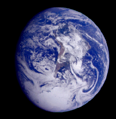
South America appears near the center of this view of Earth. The white,
sunlit continent of Antarctica lies near the bottom of the
globe. Picturesque weather fronts are visible in the South Atlantic,
lower right. This image was taken at about 14:10 UTC on December 11,
1990, when Galileo was 2 million km (1.3 million mi) from Earth.
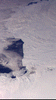 Antarctica
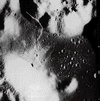
Part of Antarctica is captured in this mosaic of 11 Galileo images.
The mosaic spans about 1600 km (992 mi) across the south polar
latitudes of our planet. This part of Antarctica lies south of South
America. At lower left, the dark blue Ross Sea is visible, bounded by
the Ross Ice Shelf on the right. The Amundsen Sea is just visible at
the top and center of the images.
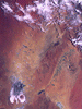 Australia
Simpson Desert, 451 km (280 mi) wide by 547 km (340 mi) long, lies
southeast of Alice Springs. At lower left is Lake Eyre, a salt lake
below sea level. Its water level changes dramatically throughout the
seasons. At the time this image was taken the lake was nearly dry. At
lower right is the greenish Lake Blanche. Fields of linear sand dunes
stretch north and east of Lake Eyre, shaped by prevailing winds from
the south. The various sources and age of the sand can be determined by
their color.
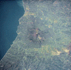 Mount Etna, Sicily
This active stratovolcano on the east coast of Sicily is almost always
venting steam into the atmosphere. Stratovolcanoes form as alternating
layers of volcanic ash and lava flows come from their central vents and
cool to form rock. During one eruption in 1969 fragments up to 1 meter
(about 3 feet) across were ejected from the volcano. This image was
acquired by Space Shuttle astronauts, and is slightly enhanced to bring
out details in the volcano. Mount Etna is over 3000 meters (10,000
feet) high, making it the highest peak in Italy south of the Alps.
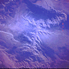
 Cassiar Mountains
This part of the Rocky Mountain Range in the Yukon Territory of Canada
is an excellent example of mountains on Earth. This space shuttle image
was taken when the sun was low on the horizon; the sharp shadows on the
snow-covered peaks show how rough and uneven the area is. These
mountains are so remote and rugged that ground surveys of the area are
very expensive. Due to remote-sensing techniques developed for
planetary exploration, many such areas can now be observed and studied
from space at much less cost and effort.
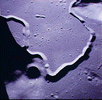
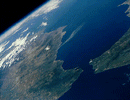 Strait of Gibraltar
This space shuttle view of the Atlantic Ocean and Mediterranean Sea
illustrates an important feature of Earth-a seacoast. Earth is the only
planet with borders of land adjacent to bodies of water because it is
the only planet where liquid water is stable at the surface. Seas are
important because water has been the catalyst for the development of
life on our planet. The Strait of Gibraltar is the border between
Africa and Europe. In Spain, to the left, the small spike of land is
the Rock of Gibraltar; Africa is on the right side of the image.
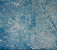 Mississippi River
This view over St. Louis, Missouri, taken in June 1991, shows the
Mississippi just left of center. The Mississippi-Missouri river system
is the third longest in the world--shorter only than the Nile in Africa
and the Amazon in South America. This river system is a meandering
river system, where flooding is often responsible for changing the
location of channels and leaving behind old riverbeds known as "meander
scars." These scars are visible in the river bottom land between the
cliffs on either side of the river.
 Grand Canyon
This space shuttle image of the Colorado River in Arizona captures the
Grand Canyon. The canyon is 30 km (18 miles) across at its widest point
and 1.6 km (1 mile) deep at rock bottom. It is 446 km (277 miles) long
and covers an area that is over 5000 square km (about 2000 square
miles). The Grand Canyon was created by the erosional action of the
Colorado River on the surface as this region has continued to rise high
above sea level over the last several million years.
 The Moon from Space
These pictures of the moon were taken by the Galileo spacecraft. The
picture at left shows the Orientale Basin, with a small, dark mare in
its center. The picture on the right shows the globe of the moon
rotated, putting Orientale on the western limb. The dark Oceanus
Procellarum is in the upper center, with Mare Imbrium above it, and the
smaller, circular Mare Humorum below.
 Apollo 17 Landing Site
Apollo 17 astronauts explored this area of the moon in December
1972. The North Massif is located at the top of the image, and the
South Massif is located at the bottom on the left. The North Massif is
more than 2 km high (1.2 mi). The terrain between the mountains is
peppered with impact craters, the largest of which is about 1 km (0.6
mi) in diameter. A bright scarp, named the Lee-Lincoln scarp, winds
around the left side of the North Massif and down through the cratered
field.
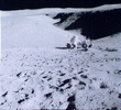
 Plum Crater
An Apollo 16 astronaut stands near the rim of Plum Crater (30m, or over
200 yards, in diameter) on the moon. Although Earth has experienced
many meteorite impacts throughout its history, the action of wind and
water quickly erases the resulting craters. Because these forces don't
exist on the moon, the only way evidence of impact craters can be
removed is by being destroyed by later impacts. However, this is not a
very efficient process so craters last a long time on the moon's
surface.
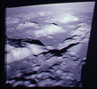
 Hadley from Space
Molten basaltic lava cut this channel, known as Hadley Rille, through
the surface of the moon. The channel winds along the base of the
Appenine Front, one of the sites explored by the Apollo 15
astronauts. It measures 1500m (nearly 1 mi) wide, 400m (433 yards)
deep, and 100 km (60 miles) long. The walls of the channel are very
steep, with slope angles of 25 to 30 degrees.
 Hadley on the Surface
An Apollo 15 astronaut looks down on the Hadley Rille, nearly 1.5 km
(.9 mi) across at its widest point. The astronauts observed layering in
the lava flows in the wall on the opposite side of the rille,
indicating that multiple lava flows formed the bedrock in this region.
 Taurus-Littrow
These highland massifs in the Taurus-Littrow region of the moon are
mountains composed of highland material--the oldest type of rock on the
moon. Between the mountains are narrow valleys where mare basalt once
flowed. This image was recorded from lunar orbit by the Apollo 17
mission to the moon. The Apollo landing site is in the upper right
quadrant of the image.
 North Massif
Apollo 17 astronaut Harrison "Jack" Schmitt is here collecting a sample
from the North Massif site, Taurus-Littrow.
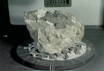 Highland Anorthosite
When the moon first formed it probably had a surface composed mostly of
feldspar-rich igneous rocks. This rock type still exists today and
makes up the lunar highlands, which is the lighter-colored part of the
moon visible from Earth. This 4.4-billion-year-old rock sample is an
anorthosite collected from the lunar highlands of the moon by Apollo 16
astronauts.
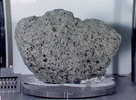 Mare Basalt
This igneous rock was collected from one of the darker areas on the
moon known as mare. The mare formed billions of years ago. Large
meteorites impacted the surface of the moon and broke up the crust.
Later lavas formed by melting of rock within the moon due to the decay
of radioactive elements. The broken crust under the big impact craters
allowed the lava to come to the surface. Over time the caters came to
be filled with lava flows. This basalt sample, estimated to be 3.7
billion years old, was collected by Apollo 17 astronauts.
 Highland Breccia
On Earth, the surface is eroded by the action of water and wind. The
most important process for altering the surface of the moon, however,
is that of meteorites impacting upon and breaking up the surface. This
lunar sample is a rock type named breccia. On the moon a breccia is
made when meteorites break up the surface and the pieces are welded
together by the heat and pressure of impact processes. This breccia was
collected by Apollo 16 astronauts and is 3.9 billion years old.
 Welcome to the Planets Home Page
 Earth in Color
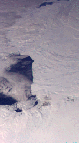 Antarctica
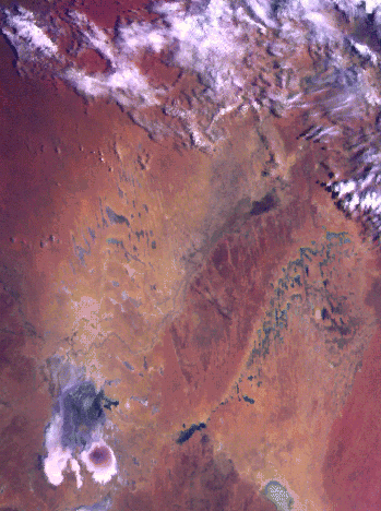 Australia
 Mount Etna, Sicily
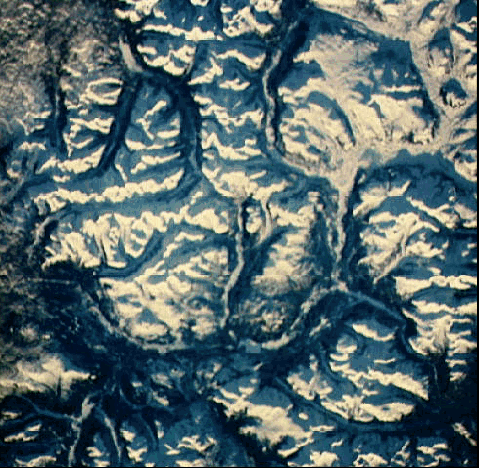 Cassiar Mountains
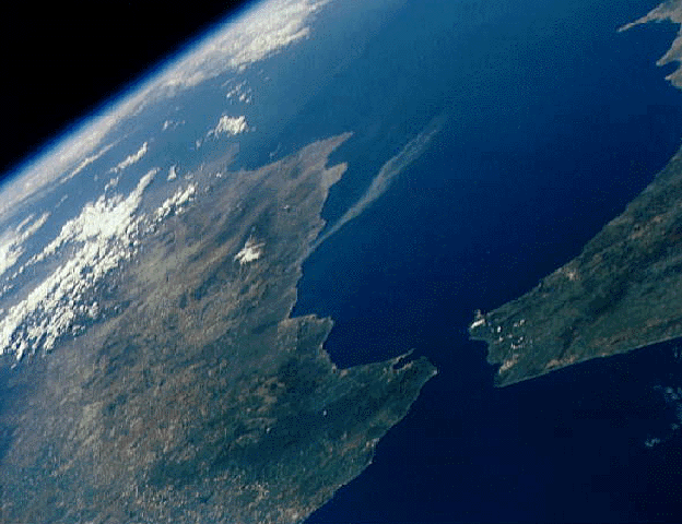 Strait of Gibraltar
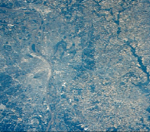 Mississippi River
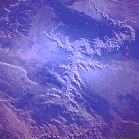 Grand Canyon
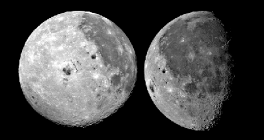 The Moon from Space
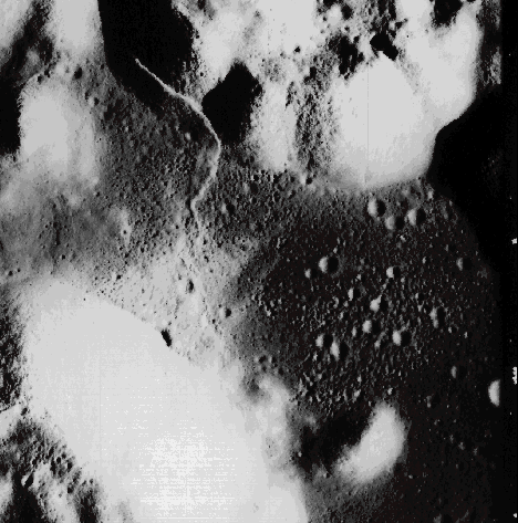 Apollo 17 Landing Site
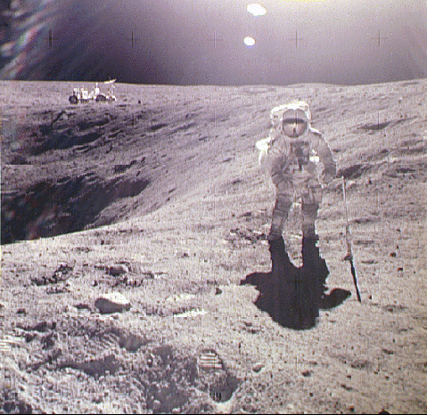 Plum Crater
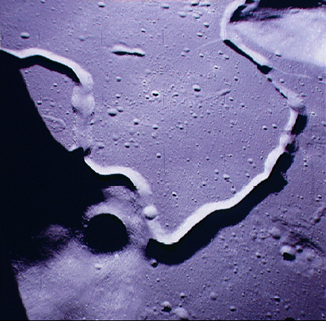 Hadley from Space
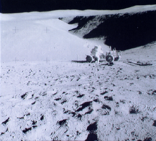 Hadley on the Surface
 Taurus-Littrow
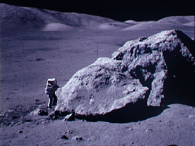 North Massif
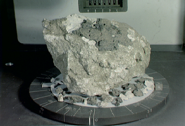 Highland Anorthosite
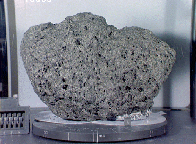 Mare Basalt
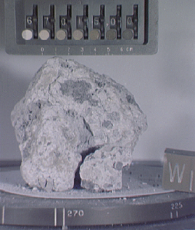 Highland Breccia