
 Uranus
Planet Profile
Mass (kg)............................................8.68 x 10^25
Diameter (km)........................................51118
Mean density (kg/m^3) ...............................1290
Escape velocity (m/sec)..............................21300

Average distance from Sun (AU).......................19.18
Rotation period (length of day) (in Earth hours).....17.9
Revolution period (length of year) (in Earth years)..84

Obliquity (tilt of axis) (degrees)...................97.9
Orbit inclination (degrees)..........................0.77
Orbit eccentricity...................................0.047

Mean temperature (K).................................59

Visual geometric albedo..............................0.56
Atmospheric components...............................83% hydrogen,
                                                     15% helium,
                                                      2% methane (at depth)
Rings................................................Uranus has
        a system of narrow, faint rings. Ring particles are dark,
	and could consist of rocky or carbonaceous material.
 Approaching
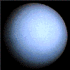
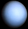
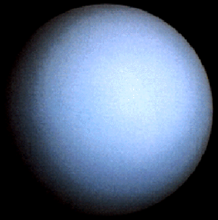
The greenish color of Uranus' atmosphere is due to methane and
high-altitude photochemical smog. Voyager 2 acquired this view of the
seventh planet while approaching the Uranian system in late January
1986. This image looks at the planet approximately along its
rotational pole.
 Dust Rings
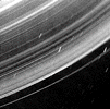
This image reveals many broad lanes of dust surrounding the 9 main
rings of Uranus. It was taken by Voyager 2 looking back toward the sun
through the ring system. The dust is especially bright in this view,
for the same reason that we can see dust on a windshield better when
we are driving toward the sun. The rings of Uranus are actually very
dark; their albedo is only a few percent. The short stubby streaks are
stars slightly smeared during the long exposure.
 Rings in False Color
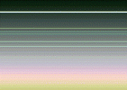
The 9 main rings of Uranus are visible here as horizontal lines. The
somewhat fainter, pastel lines seen between the rings are artifacts of
computer enhancement. Six narrow-angle images were used to extract
color information from the extremely dark and faint rings. The final
image was made from three color averages and represents an enhanced,
false-color view. The image shows that the brightest, or epsilon ring
at top is neutral in color, with the fainter 8 remaining rings showing
slight color differences between them.
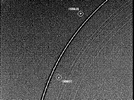 Shepherd Satellites
The discovery of two "shepherd" satellites has advanced our
understanding of the structure of the Uranian rings. The moons,
designated 1986U7 (Cordelia) and 1986U8 (Ophelia), are seen here on
either side of the bright epsilon ring and are believed to confine it
by their gravitational effects. Inward from the epsilon ring are the
delta, gamma, eta, beta and alpha rings. The 4, 5, and 6 rings are
barely visible inward from there. The rings have been studied since
their discovery in 1977. The epsilon ring appears surrounded by a
dark band as a result of the image processing.
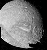
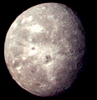
 The Chevron
Miranda is the innermost of the large Uranian satellites. Its surface
is composed mostly of rolling cratered plains that probably date back
to the early evolution of the solar system when impact rates were
extremely high. The other half is younger based on the fewer number of
craters; it consists of complex sets of parallel and intersecting
scarps and ridges. The bright V-shaped feature in the grooved area is
Inverness Corona, and has been nicknamed the "Chevron". The huge,
jagged canyon on the right limb is in the direction of Uranus itself.
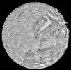
 Miranda Mosaic
The images which make up this mosaic of Miranda are among the highest
resolution pictures that Voyager obtained of any of the new worlds it
encountered during its mission. On Miranda, ridges and valleys of one
province are cut off against the boundary of another. Probable
compressional folded ridges are seen in arcuate patterns, as are many
extensional faults. Some of these show large scarps ranging from 0.5 -
5 km (0.3 - 3 mi) in height -- higher than the walls of the Grand
Canyon on Earth.
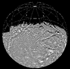
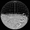 Global Mosaic
Most of these views of Miranda were acquired from below the south polar
region and were rotated by computer programs to make this image of the
equator. The large oval racetrack-like region near the equator, called
a corona, is due to more recent geologic activity that changed part of
the crust by a combination of tectonic and volcanic forces. One theory
is that these regions represent the top of a rising mantle plume.
 Miranda's South Pole
The Chevron is an unusual feature on the surface of Miranda. The small
number of craters indicates that this extensive system of faults is
younger than the surrounding heavily cratered terrain. Some of the dark
material inside the Chevron may be igneous material ejected along the
fault planes. The lower image offers a perspective view of the same
region shown in the top. It was generated from a computer model of the
surface topography. The relief is exaggerated by about 50- fold; the
view angle is about 15 degrees above the horizon.
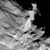 Dramatic Miranda
Miranda displays a dramatically varied surface. Easy to see in this
660m- (2160 ft-) wide image are numerous ridges and valleys -- a
topography that was probably produced by compressional
tectonics. Cutting across the ridges and valleys are many faults. The
largest fault scarp is seen below and right of center; it shows grooves
probably made by the fault blocks as they rubbed against each other
(leaving what are known as slickensides). Movement of the down-dropped
block is shown by the offset of the ridges. The fault may be 5 km (3
mi) high, or higher than the walls of the Grand Canyon on Earth.
 Partial Mosaic
The second large satellite of Uranus reveals a complex geologic
history. Global fracturing coupled with the eruption of icy volcanic
fluids (as cold as 175 K) have marred its surface. The original Voyager
images were projected onto a sphere to provide this unique view of
Ariel.
 Intense Cratering
The complex terrain of Ariel is captured in this view of its southern
hemisphere. Most of the surface consists of intensely cratered terrain
transected by fault scarps and graben. Some of the largest graben,
which can be seen near the terminator (at right), are partly filled
with younger deposits that are less heavily cratered. Bright spots near
the limb and toward the left are chiefly the rims of craters. Most of
the brightly rimmed craters are too small to be resolved here, although
one crater about 30 km (20 mi) in diameter is easy to spot near the
center.
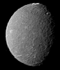 Mysterious Umbriel
Umbriel is an enigma. It has a surface albedo of only 10-15%, while the
rest of the Uranian satellites found inside and outside Umbriel's orbit
are much brighter. The process by which Umbriel's ancient cratered
surface was darkened, leaving only a few bright icy white rings,
remains a mystery.
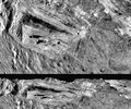
 Intersecting Valleys
The abundance of impact craters and prominent global tectonic features
on Titania are obvious in this image. The large fault valleys are some
1500 km (930 mi) long and 75 km (47 mi) wide. Near the bottom of the
image the valley Messina Chasmata cuts through the impact crater
Ursula (200 km or 124 mi in diameter). This high-resolution image was
taken at a distance of 369,000 km (229,000 mi). Note that Titania's
south pole is toward the left, since it rotates about Uranus' equator,
approximately perpendicular to the ecliptic plane.
 Diverse Geology
The surface of Titania has recorded many different types of geologic
activity throughout its history. In addition to numerous impact scars,
there is a large, trench-like feature near the terminator at middle
right that suggests at least one episode of tectonics. A basin-like
structure is visible near the upper right of the image. The neutral
gray color of Titania is characteristic of all the Uranian
satellites. Surface details about 9 km (6 mi) in size are
visible. Titania has a diameter of 1600 km (1000 mi).
 Outermost Moon
This is the best spacecraft-acquired image of Uranus' outermost moon
Oberon. Several large impact craters, surrounded by bright rays, are
visible in this view. Near the center of Oberon's disk is a large crater
with a bright central peak and a floor partially covered with black
material. This may be icy, carbon-rich material that spilled onto the
crater floor sometime after the crater formed. Another striking feature is
a large mountain, about 6 km (4 mi) high, peeking out on the lower left
limb.
 Welcome to the Planets Home Page
 Approaching
 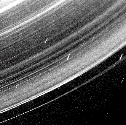 Dust Rings
 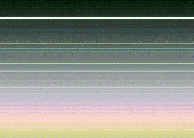 Rings in False Color
 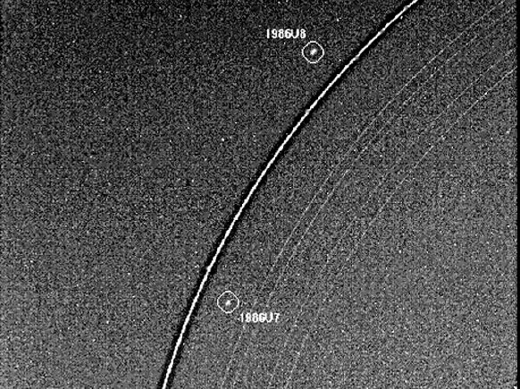 Shepherd Satellites
 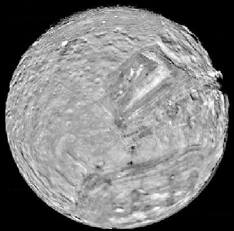 The Chevron
 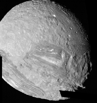 Miranda Mosaic
 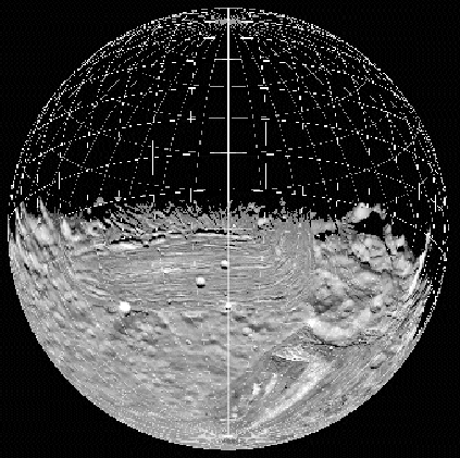 Global Mosaic
 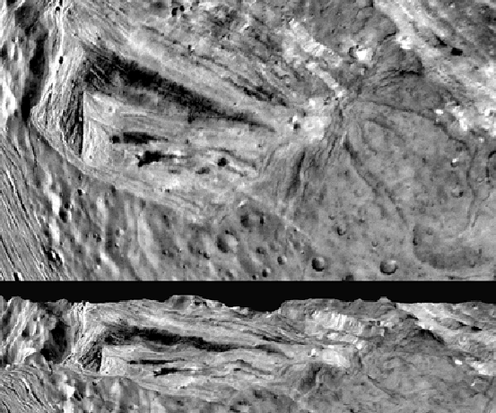 Miranda's South Pole
  Dramatic Miranda
 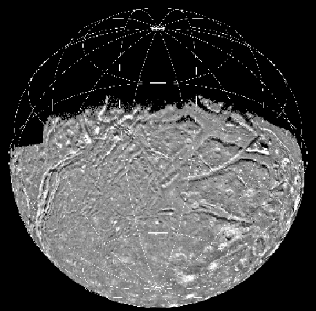 Partial Mosaic
 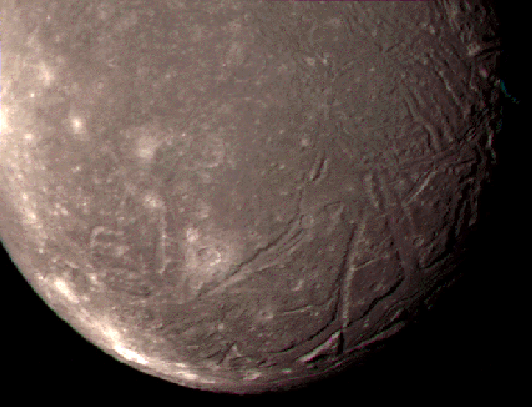 Intense Cratering
  Mysterious Umbriel
 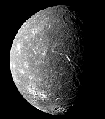 Intersecting Valleys
 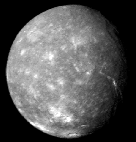 Diverse Geology
 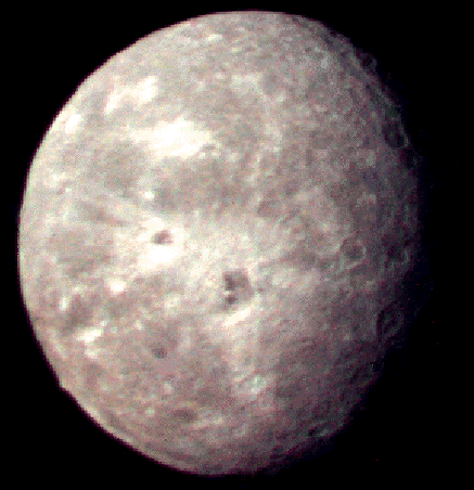 Outermost Moon