
 Venus
Venus
Planet Profile
Mass (kg)............................................4.87 x 10^24
Diameter (km)........................................12104
Mean density (kg/m^3) ...............................5250
Escape velocity (m/sec)..............................10400

Average distance from Sun (AU).......................0.723
Rotation period (length of day) (in Earth days)......243.0 (retrograde)
Revolution period (length of year) (in Earth days)...224.7

Obliquity (tilt of axis) (degrees)...................178
Orbit inclination (degrees)..........................3.39
Orbit eccentricity...................................0.007

Mean surface temperature (K).........................726

Visual geometric albedo..............................0.59
Highest point on surface.............................Maxwell Montes
                                (17 km above mean planetary radius)
Atmospheric components...............................96% carbon dioxide,
                                                      3% nitrogen,
                                                      0.1% water vapor
Surface materials....................................basaltic rock and
						     altered materials
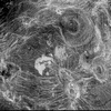
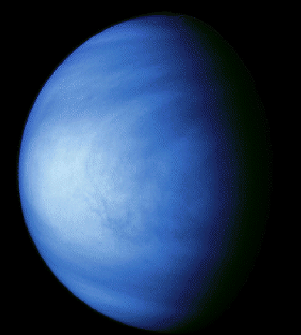
 Venus in Color
The bluish hue of Venus is an effect of the colorization technique used
to enhance subtle contrasts in cloud patterns and indicates that this
image was taken through a violet filter. Features in the sulfuric acid
clouds near the top of the planet's atmosphere are most prominent in
violet and ultraviolet light. This image shows the east to west cloud
banding and the brighter polar hoods. The features are embedded in
winds that flow from east to west at about 370 kph (230 mph).
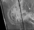
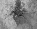
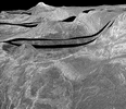
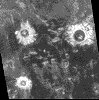 Impact Craters
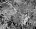
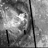
Three large impact craters with diameters ranging from 37 km (23 mi)
to 65 km (40 mi) are visible in the fractured plains. Features typical
of meteorite impact craters are also visible. Rough radar-bright
ejecta surrounds the perimeter of the craters; terraced inner walls
and large central peaks can be seen. Crater floors appear dark because
they are smooth and have been flooded by lava. Domes of probable
volcanic origin can be seen in the southeastern corner. The domes
range in diameter from 1-12 km (0.6-7 mi); some have central pits
typical of volcanic shields or cones.
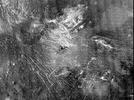 Bright Plains
Located along the left central edge of the image is a cluster of
volcanic domes that ranges from 1.5 km (1 mi) to 7.5 km in diameter (5
mi). The domes and their deposits are located at the convergence of
radar-bright lineaments that are interpreted to be faults and
troughs. In some places the domes overlie the faults. The faults and
troughs extend into the lower part of the image where they terminate
against dark plains deposits and are crosscut at right angles by
additional faults. The relationship between these features indicates
that multiple episodes of faulting and volcanism have occurred.
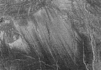
 Ovda Regio
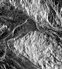
The tectonic fabric of this region of Ovda Regio trends predominantly
east-west. The large radar-dark areas are probably tectonically formed
basins that have been filled in by fluid lava flows, thus presenting a
smooth surface to the Magellan radar system.
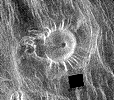
 Ridges and Troughs
On this bright, lineated terrain Alpha Regio is a series of troughs,
ridges, and faults running in every direction. The lengths of these
features range from 10 km (6.3 mi) to 60 km (37 mi). The elevation of
Alpha Regio varies over a range of 4 km (2.5 mi). Low-lying areas
appear dark in the radar images and may be filled with lava. Volcanoes
appear as bright spots on the smooth plains. Notice the large volcano
in the upper right. At the center of this 35 km (22 mi) volcano is a
caldera; its western edge appears to be either a debris flow or a lava
flow. The black square represents missing data.
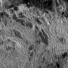
 Highlands
Several tectonic events formed this complex terrain, which is part of
the interior of Ovda Regio. An underlying fabric of ridges and valleys
lies NE-SW. These ridges are spaced 10-20 km (6-12 mi) apart and may
have been caused by compression of the crust at right angles to the
ridge. The ridges are cut by bright features extending NW-SE. The
largest valleys, particularly the 20 km (12 mi) wide valley extending
across the image, were filled with dark material, probably lava. The
complexity of Ovda Regio attests to a long history of tectonic
deformation.
 Eastern Lakshmi
Lava flows blanket the flat plains region of eastern Lakshmi. The dark
flows most likely represent smooth flows similar to pahoehoe flows on
Earth, while the brighter areas are rougher flows resembling Earth's aa
flows. Three dark splotches mark the tops of these lava flows. Because
of the thick atmosphere surrounding Venus, small impactors break up
before they hit the surface. The fragments are deposited over the
surface and produce the dark splotches seen here. Notice the splotch on
the far right has a crater at its center, indicating that the impactor
was not completely destroyed.
 Lava Flows
This mosaic highlights a system of east-trending, radar-bright and dark
lava flows that collide with and breach a north-trending ridge belt
(left of center). Upon breaching the ridge belt, the lava pooled,
forming a radar-bright deposit approximately 100,000 square km (right
side of image). The source of the lava is the caldera Ammavaru, which
lies about 300 km (186 mi) west of the scene. The bright and dark bars
extending from top to bottom are artifacts of image processing.
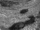
 Coronas in Fortuna
Two large oval coronae can be seen in this image of Fortuna. On the
left is Bahet Corona, 230 km (138 mi) long and 150 km (90 mi) across. A
portion of Onatah Corona, over 350 km (210 mi) in diameter, is visible
on the right. Both features are surrounded by a ring of ridges and
troughs. The central areas of the coronae contain radial fractures as
well as volcanic domes and flows. Coronae may form due to the upwelling
of hot material from deep in the interior of Venus. These two coronae
may have formed at the same time over a single upwelling. The black
strip represents missing data.
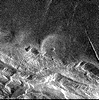
 Lavinia Region
The bright area running from the upper right to the lower left may be
part of a belt of ridges formed by compression and thickening of the
upper layers of the planet. The area between the ridges suggests
flooding by lava flows. The varied textures of the lava can be seen in
the mottled appearance of the plains, which have been cut by the
ridges; brighter, rougher flows are also quite common. The lighter area
in the lower right corner is the northern extension of Mylitta
Fluctus. The black strip represents missing data.
 Arachnoids
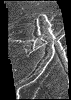
Named by the Soviets for their spider and cobweb-like appearance,
arachnoids are one of the more remarkable features found on Venus. They
are 50 to 230 km (30 to 138 mi) diameter circular structures, with a
central volcanic feature surrounded by a complex network of
fractures. Arachnoids are similar in form but generally smaller than
coronae. The radar- bright lines extending for many kilometers beyond
the arachnoids may have been caused by an upwelling of magma from the
interior of Venus, which pushed up the surface to form cracks.
 Pandora Corona
Located in Lada Terra, Pandora Corona measures 350 km (210 mi) in
diameter. Coronae are circular to elliptical features marked by a ring
of concentric ridges, and are thought to result from the flow of heat
in the planet's interior. As hot material rises, it weakens the upper
layers of the crust, causing the surface to dome upwards. Then as the
region cools, the dome begins to subside. As the upper layers rise and
fall, they are subjected to stresses that crack the surface, creating
both circular and radial fractures. The black strips represent missing
data.
 Corona
This region, roughly 100 km (60 mi) on a side, shows a gigantic
structure known as a corona. Such features are thought to be the result
of hot rising bodies of magma that reach the crust, and cause it to
partially melt and collapse, generating volcanic flows and fault
patterns that radiate from the central structure. Magellan acquired
this view of Venus during its first mapping cycle around the planet in
1990 and 1991.
 Sacajawea Patera
Sacajawea Patera is a huge caldera located in western Ishtar Terra. It
measures approximately 233 km (140 mi) wide at its base, 1-2 km (0.6
-1.2 mi) deep and 120 by 215 km (74 by 133 mi) in diameter. The caldera
is bounded by a zone of graben and fault scarps. Extending up to 140 km
(87 mi) in length from the southeast of the caldera is a system of
linear structures thought to be a flanking rift zone along which the
lateral injection and eruption of magma may have occurred.
 Domical Hills
Seven circular domes can be seen on the eastern edge of Alpha
Regio. They average 25 km (15 mi) in diameter with maximum heights of
750 m (2475 ft). Some scientists believe they are the result of
eruptions of thick lava that flowed from a vent on level ground,
resulting in an even lateral pattern of lava. The concentric and radial
fracture pattern on the surface of the domes suggests that lava welled
up inside the domes, causing the surface to stretch.
 Ticks
Ticks
Scientists nicknamed this type of volcano a tick. About 66 km (41 mi)
across at the base, this volcano has a flat, concave summit 35 km (22
mi) in diameter. The sides of the volcano are characterized by
radiating ridges and valleys. To the west, the rim of the volcano
appears to have been breached by dark lava flows that emanated from a
shallow summit pit (5.4 km/3.3 mi in diameter) and traveled west along
a channel. The black square represents missing data.
 Danu Mountains
The Danu Mountains bound Lakshmi Planum to the south. Because of the
steep slopes, the local relief in the area (2-3 km/1-2 mi), and the
effects of radar geometry, the fault- bounded troughs appear to zigzag
through the area when in reality, they are likely straight when viewed
from above. The large volcanic dome is 20 km (12 mi) in diameter and
was deformed when the Danu Mountains were created.
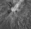 Gula Mons
Towering 4 km (3 mi) above the surface in NW Eistla Regio is the shield
volcano Gula Mons. This type of volcano is similar to those found on
the Hawaiian Islands; possibly resulting from hot material rising from
the interior and heating the crust. Shield volcanoes form when hot,
fluid lava erupts non- explosively. The radar-bright area in Eistla
Regio consists of both the summit and radial troughs and scarps
extending to the northeast down the slope of Gula Mons. Regional
expansion of the crust is obvious in this area because of the presence
of graben.
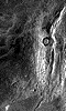
 Golubkina
This is a Magellan image of Crater Golubkina. The 30 km- (18 mi-)
diameter crater is characterized by terraced inner walls and a central
peak, typical of large impact craters on the Earth, Moon and Mars. The
terraced inner walls take shape late in the formation of an impact
crater, due to the collapse of the initial cavity created by the
meteorite impact. The central peak forms due to the rebound of the
inner crater floor. This crater is named after the Russian sculptor
Anna Golubkina.
 Crater Perspective
This is a computer generated, perspective view of Crater Golubkina.
Vertical exaggeration in this image is about 20 times.
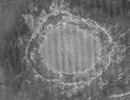 Largest Crater
Crater Mead is the largest known crater on Venus. Named after Margaret
Mead, the American anthropologist, it measures 280 km (168 mi) in
diameter and is located north of Aphrodite Terra and east of Eistla
Regio. Classified as a multi-ring crater, Mead's innermost ring is
thought to be the rim of the original crater cavity. The presence of
irregular, radar-bright crater ejecta crossing the radar-dark floor
terrace and adjacent outer radar-bright ring suggests that the terrace
floor region is likely down-dropped and tilted outward, forming a
concentric ring-fault.
 Half Crater
This remarkable half crater called Somerville is located in the rift
between Rhea and Theia Montes in Beta Regio. ( Radar illumination is
from the left. ) About 37 km (23 mi) in diameter, Somerville has been
cut by many fractures or faults since it was formed by the impact of a
large meteorite. The eastern portion was partially destroyed during the
formation of a fault- valley, which measures up to 20 km (12 mi)
wide. A north- south profile through the center of this crater resulted
from the downdropping and removal of most of the eastern half of the
crater.
 Akna Mountains
The Akna Mountains form the western edge of Lakshmi Planum. Wanda, the
giant crater on the upper right, has a diameter of 18 km (11 mi). While
Wanda doesn't appear to have been deformed by tectonics, material from
the Akna Mountains appears to have collapsed into it. The area
represented by this image is about 200 km (124 mi) long by 125 km (78
mi) wide.
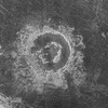
 Craters in Transition
Magellan's radar system detected few impact craters in the process of
being resurfaced by volcanism. Alcott is the largest of these craters
in transition, with a diameter of 63 km (39 mi). The trough-like
depression (lower left) is a rille through which lava once flowed. A
remnant of rough radial ejecta is preserved outside the crater's
southeast rim. The presence of partially lava-flooded craters such as
this is important to our understanding of the rate of resurfacing on
Venus by volcanism.
 Peak-Ring Crater
This 54-km (32-mi) diameter crater is the size at which craters on
Venus begin to possess peak-rings instead of a single central peak. The
floor of Barton crater is flat and radar-dark, indicating possible
infilling by lava flows sometime following the impact. Barton's central
peak-ring is discontinuous and appears to have been disrupted or
separated during or following the cratering process. The name Barton
has been proposed by the Magellan Science Team, after Clara Barton,
founder of the U. S. Red Cross; the name is tentative pending approval
by the IAU.
 Dark Halos
Impact craters such as Crater Carson shown here are frequently
surrounded by radar-dark halos. Several of these special craters have
halos that are parabolic in shape and are very long, extending hundreds
of kilometers to the west. The darkness of the emissivity data
indicates a smooth surface, leading scientists to believe that halos
may be thick, smooth sediment deposits formed when incoming projectiles
crashed into the surface. The black strips represent missing data.
Arrows show the easternmost boundary of the halo.
 Large Impact Crater
A large impact crater about 30 km (19 mi) in diameter is surrounded by
a fresh ejecta blanket. The extreme brightness of the blanket is due to
its roughness and its ability to scatter the radar signals that are
used to collect these images. Scientists believe that the missing
section of the ejecta blanket is due to an atmospheric blast that
followed the impactor as it crashed through the Venusian atmosphere.
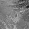
 Long Channel
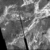
This long open channel in Vires-akka Chasma ranges in width from under
1 km (3300 ft) to 4 km (2 mi). The portion of the channel visible here
is over 120 km (72 mi) long. Scour lines are visible along the length
of the channel, particularly where it makes abrupt turns. The channel
may have been carved by very fluid lava that remained liquid as it
flowed over great distances due to the extreme surface
temperatures. Because the lava remained fluid it eroded preexisting
terrain along its path.
 Fault-Bounded Troughs
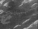
The large fault-bounded trough in the center of the image was nicknamed
Gumby (after an animated cartoon figure) by Magellan
scientists. Located in the Lavinia region at the intersection of two
tectonic trends, Gumby measures 5 km (3 mi) wide and 100-200 m (.06 -
.1 mi) deep. An example of one of the trends is the bright lines
running E-W through Gumby's head. A second example is the bright lines
running SW to NE through Gumby's legs and hips. The line of pits (by
Gumby's elbow) suggests some igneous or volcanic activity may have
accompanied the faulting.
 Tributary-Like Branches
In a region near Hestia Rupes on the NW corner of Aphrodite Terra lies
a complex network of narrow (<1 km) bright channels. This network
exhibits tributary-like branches similar to those observed in river
systems on Earth. However, the angular intersections of these
tributaries suggest control by faulting. The tributaries may be due to
drainage of lava along preexisting fractures. The main tectonic fabric
of this region can be observed in the NE-SW trending ridges.
 Radar Bright
This pair of images shows a region in Aphrodite Terra. The left image
was taken in November 1990 and the right image in July 1991. In the
center of the right image lies a bright, flow-like area extending to
the left of a bright fracture. When the bright rough area appeared, the
fracture seemed to change position from when the image on the left was
taken. Some scientists thought a "Venusquake" had occurred, causing a
landslide (the bright area) to form. Later analyses indicated that the
apparent changes in the surface were due to differences in radar
illumination.
 Ash on Lava
In northern Navka, radar-dark wind streaks have been blown across
radar-dark lava flows, indicating a SE-NW wind direction. The darkness
of the streaks indicates they are composed of small, fine-grained
material that is too smooth to return a strong radar signal. The
radar-dark lava flows beneath the streaks are dark because they are
smoother than the rougher, radar-bright lava flows to the left. Because
the streaks are associated with lava flows, they may be composed of
fine ash from the volcanic eruption that produced the flows.
 Wind Streaks
Spectacular wind streaks were found NE of Crater Mead. The powerful
impact that created Mead spread debris 500 km (310 mi) onto the
surrounding plains. The radar-bright streaks in this image most likely
represent debris from the impact that have been modified by surface
winds blowing from northwest to southeast. The radar-bright material
is on top of an older, darker terrain.
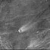 Crater with Streak
The comet-like tail lying northeast of this volcano is a relatively
radar-bright deposit. The streak is 35 km (22 mi) long and 10 km (6 mi)
wide. The volcano, whose diameter is 5 km (3 mi), blocks the wind so
that particles in the atmosphere settle downwind from it.
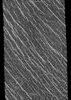 Parallel Lines
Two groups of parallel features that intersect almost at right angles
are visible. The regularity of this terrain caused scientists to
nickname it "graph paper" terrain. The fainter lineations are spaced at
intervals of about 1 km (.6 mi) and extend beyond the boundaries of the
image. The brighter, more dominant lineations are less regular and
often appear to begin and end where they intersect the fainter
lineations. It is not yet clear whether the two sets of lineations
represent faults or fractures, but in areas outside the image, the
bright lineations are associated with pit craters and other volcanic
features.
 Lakshmi Planum
The southern scarp and basin province of western Ishtar Terra are
portrayed in this vertically exaggerated 3-dimensional perspective
view. Western Ishtar Terra is about the size of Australia and is a
major focus of Magellan investigations. The highland terrain is
centered on a 2.5 km to 4 km-high (1.5 mi to 2.5 mi-high) plateau,
Lakshmi Planum, which can be seen in the distance at the right. Here,
the surface of the plateau drops precipitously into the bounding
lowlands. Vertical exaggeration in this image is about 20 times.
 Sif Mons
Located on the slopes of Sif Mons, this area displays a simple sequence
of events. The small shield volcanoes, features commonly found on
Earth, are no more than 5 km (3 mi) in diameter. The dark background
plains and the shield volcanoes both formed from the eruption of very
fluid lava. Over time, several layers of lava flows covered each other,
each one successively brighter, indicating that they became blockier in
texture over time. The summits of the shield volcanoes protrude from
the flows. Once the lava flows were in place, fractures formed as the
new surface expanded.
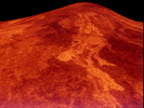 Recent Volcanism
This false-color view of the volcano Sif Mons was generated from
Magellan SAR data and existing altimetry data. The image shows a region
of the volcano just below the summit of the peak. A series of bright
and dark lava flows is visible in the foreground. The brightest flows,
which are relatively rough, are associated with the most recent
volcanism in the region. The flows overlay older lava flows which are
smoother and hence appear darker to the Magellan radar system. The
volcano is 2 km (1.2 mi) high and 200 km (120 mi) in diameter. Vertical
exaggeration in this image is about 20 times.
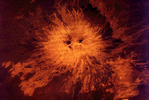 Twin Summit
Located in the Atla Regio region of Venus is Sapas Mons. The sides of
the volcano are covered with numerous overlapping lava flows, many of
which appear to have originated along the sides of the volcano rather
than from its double summit. This type of eruption is common of large
shield volcanoes on Earth, such as those found in Hawaii. Color was
artificially added to this image and is based on the colors that the
Soviet Venera 13 and 14 spacecraft observed in the 1970s.
 Welcome to the Planets Home Page
 Venus in Color
 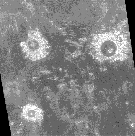 Impact Craters
 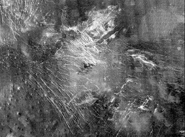 Bright Plains
 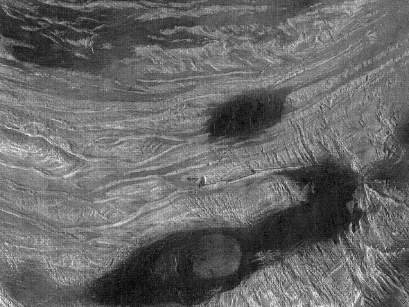 Ovda Regio
 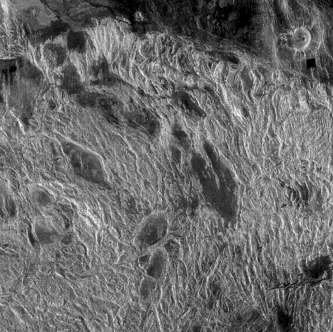 Ridges and Troughs
 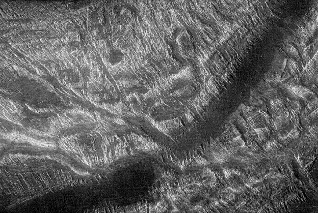 Highlands
 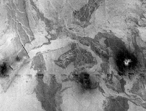 Eastern Lakshmi
  Lava Flows
  Coronas in Fortuna
 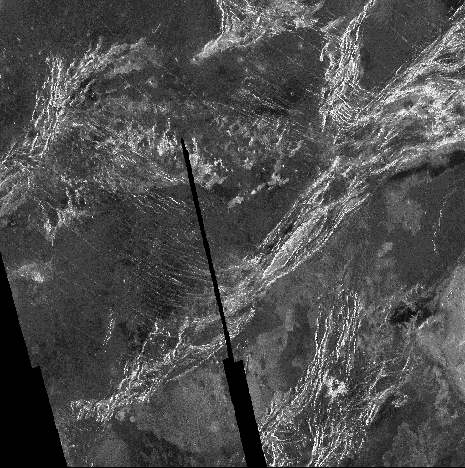 Lavinia Region
  Arachnoids
 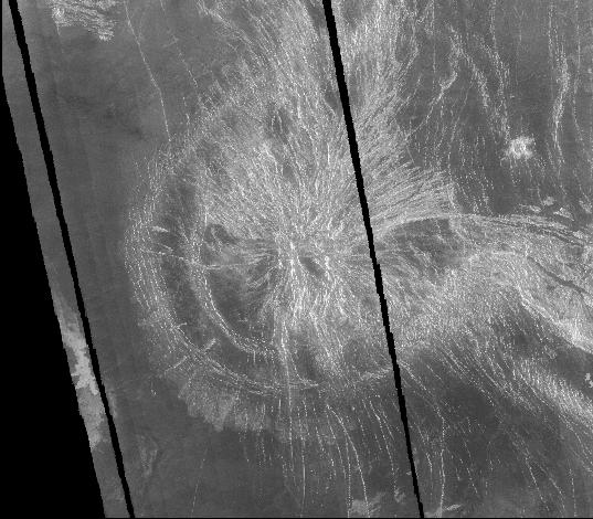 Pandora Corona
 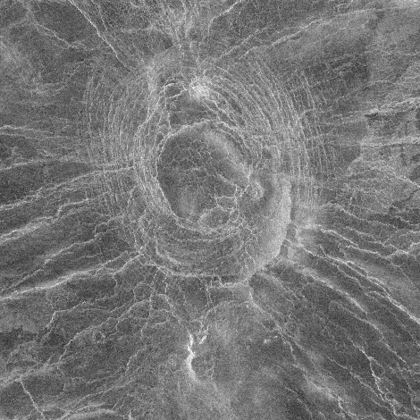 Corona
 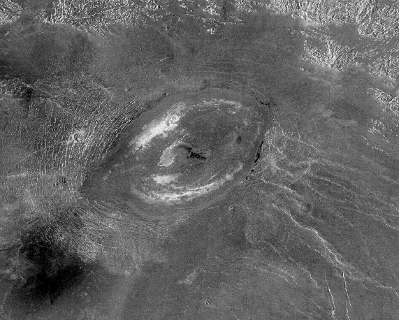 Sacajawea Patera
 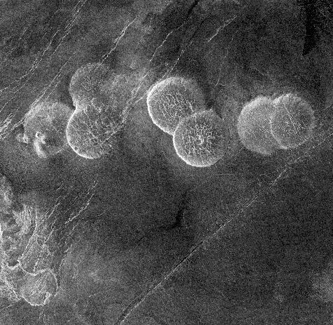 Domical Hills
 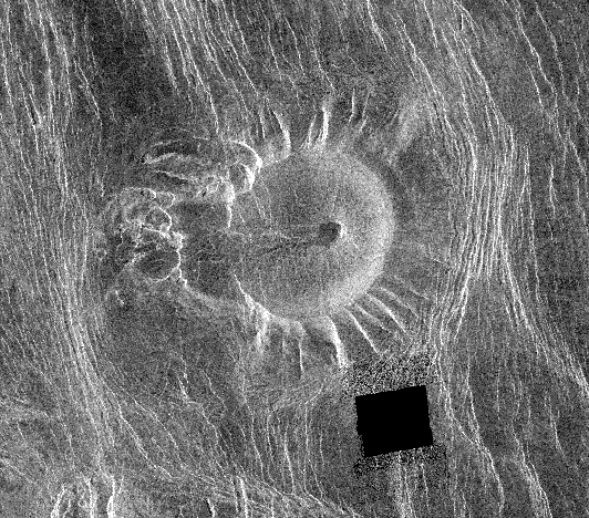 Ticks
Ticks  Danu Mountains
 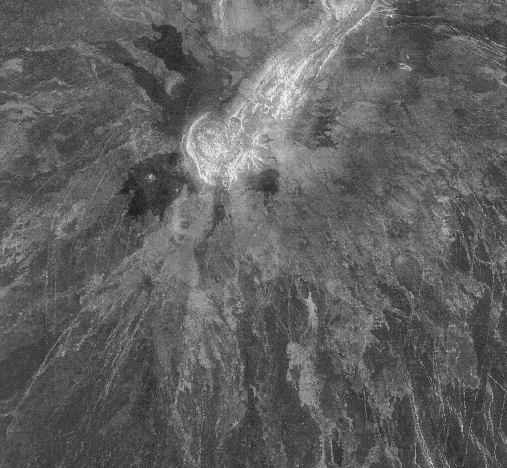 Gula Mons
 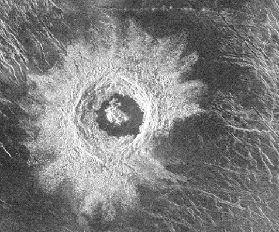 Golubkina
 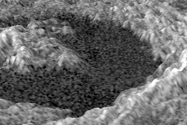 Crater Perspective
 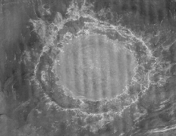 Largest Crater
 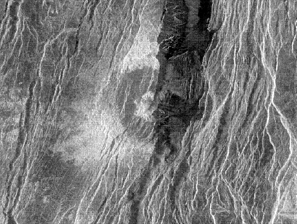 Half Crater
 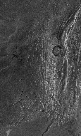 Akna Mountains
 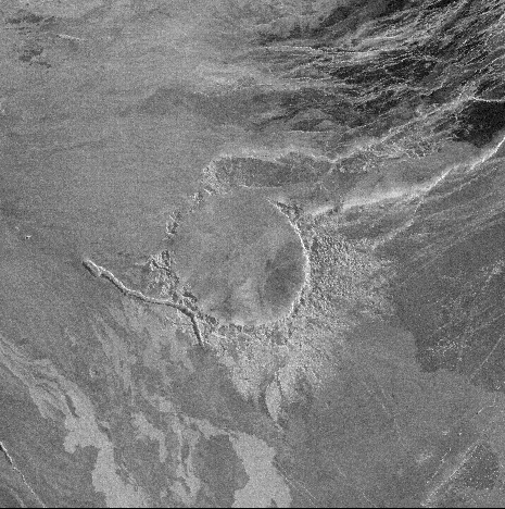 Craters in Transition
  Peak-Ring Crater
 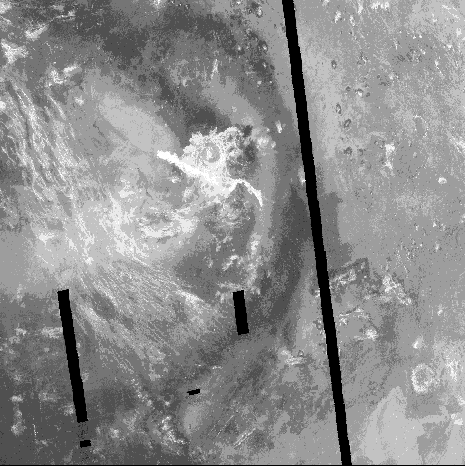 Dark Halos
  Large Impact Crater
 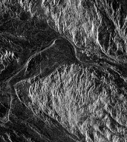 Long Channel
 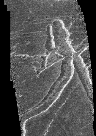 Fault-Bounded Troughs
  Tributary-Like Branches
 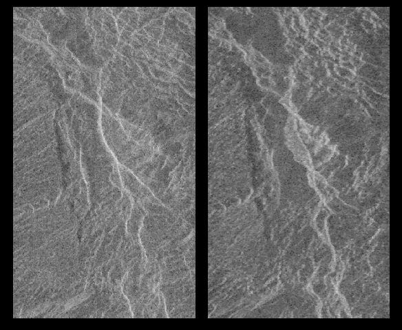 Radar Bright
 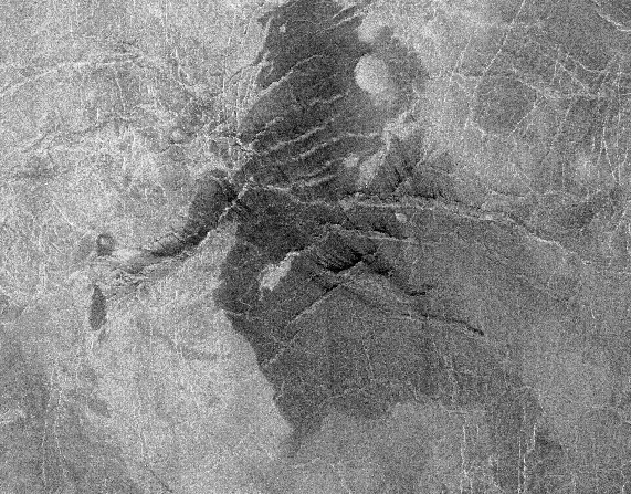 Ash on Lava
 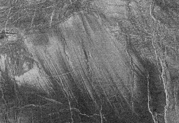 Wind Streaks
 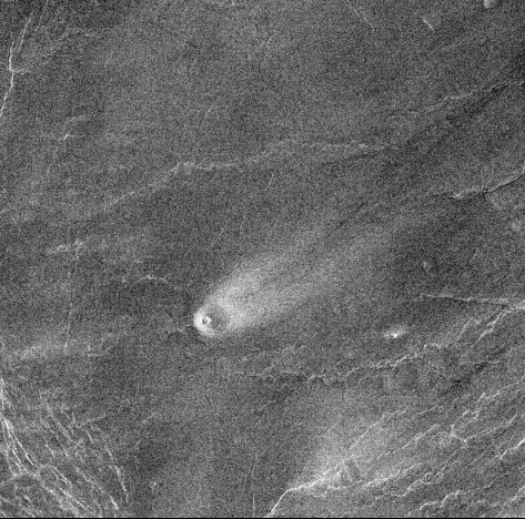 Crater with Streak
 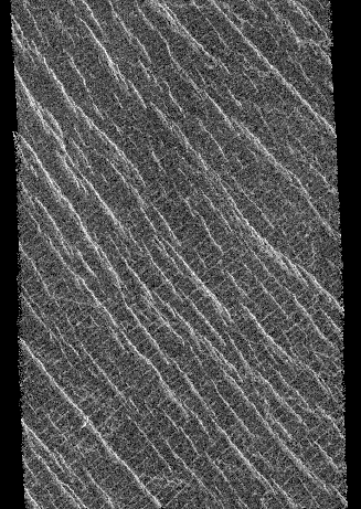 Parallel Lines
 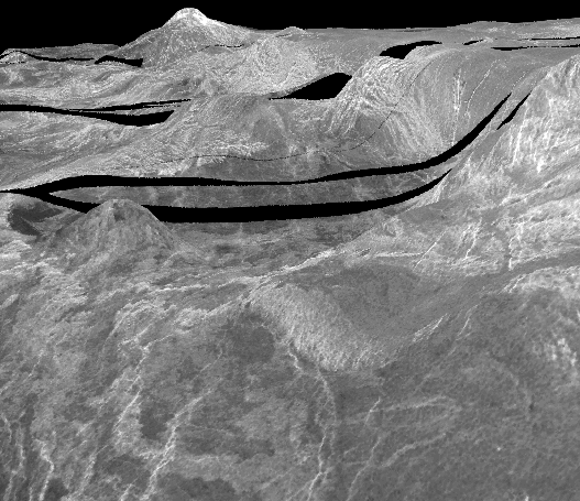 Lakshmi Planum
 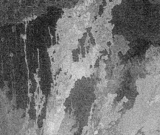 Sif Mons
  Recent Volcanism
 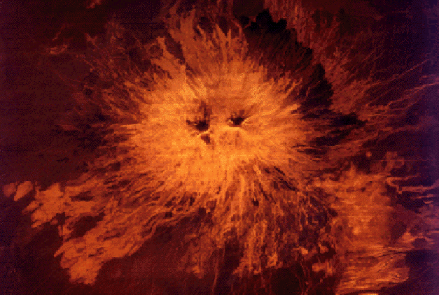 Twin Summit